


Words Robert Crack Pics Carolyne Jasinski and Robert Crack
The Reynolds River Track is a 44km, 4WD-only route that cuts through the heart of Litchfield National Park, NT.

(Credit: Carolyne Jasinski)
There was a time when I wouldn’t need to think twice about jumping in the car and heading to Litchfield National Park just for a swim.
That was a no-brainer when I lived in Darwin.
Nowadays, the inviting waters of Florence Falls, Buley Rockhole, Wangi Falls and Walker Creek are around a 3700km drive away, so a day trip for a swim isn’t quite possible.
Even if it were, at time of writing most of the swimming holes in Litchfield National Park are currently closed.
The sealed roads in are open and so too are the campground at Wangi Falls and the two campgrounds at Florence Falls. But Wangi and Florence are closed for swimming, as are Buley Rockhole and Walker Creek.
Wangi Falls is unlikely to open until May after the wet season (November to April), and after Parks and Wildlife Commission of the Northern Territory (PWCNT) rangers complete their crocodile surveys.
The PWCNT website lists Buley Rockhole as being closed due to dangerous conditions, while Florence Falls is closed due to dangerous flow and access issues. Walker Creek is closed due to the walking track being inundated with fast flowing water.
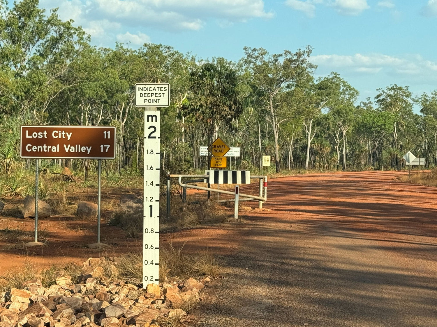
So, with the notable exception of Upper Cascades swimming area, there’s currently no swimming to be had in Litchfield right now. Even the Lost City is closed due to flooding. And as the Reynolds River Track, Tjaynera Falls (Sandy Creek Falls), Sandy Creek Campground, Surprise Creek Falls and Surprise Creek Campground are all seasonally closed due to impassable site access, one could be forgiven for asking, why is Hema Maps writing about Litchfield National Park in the middle of the wet season?
Simple really.
Because the Reynolds River Track is forecast to reopen in June, making now the perfect time to start planning your dry season travels!
Rough and remote
Most travellers roll into Litchfield National Park expecting easy roads, signposted waterfalls and a gentle introduction to the Top End.
That’s exactly why the Reynolds River Track still keeps a low profile.
Hidden deep in the southern half of the park, this seasonal 4WD route delivers a very different experience — rough, remote and deliberately unmanaged. It’s only around 90 minutes from Darwin, yet it feels a long way removed from crowds, bitumen and comfort.
This is Litchfield with the safety rails taken off.
What is the Reynolds River Track?
The Reynolds River Track is a 44km, 4WD-only route that cuts through the heart of Litchfield National Park, linking Litchfield Park Road in the north to Daly River Road in the south.
It is dry season only, typically open from May or even June to September, and gated at both ends.
From the turn-off, signage makes the message clear: high-clearance 4WD vehicles only. No exceptions.
Once committed, drivers can expect multiple river crossings, heavy corrugations, rocky washouts and long, bone-rattling sections of uneven track.
It’s not technical in the rock-crawling sense, but it demands patience, preparation and a vehicle that’s properly set up.
Reynolds is not a track that forgives mistakes.

(Credit: Carolyne Jasinski)
Landscape on the move
The track winds through a constantly shifting landscape — sandstone escarpments give way to monsoonal rainforest pockets, then open savannah woodland and floodplain.
For those who slow down and pay attention, wildlife sightings are common.
Buffalo graze in the distance. Birdlife flits through the paperbarks and woollybutts. Antilopine Wallaroo and Agile Wallaby sightings are not uncommon. This is living country, not a curated attraction.

Feral swamp buffalo (Bubalus bubalis) (Credit: Carolyne Jasinski)
River crossings (and the crocodile question)
There are four main river crossings along the track.
In the dry season, most crossings are shallow — often less than half a metre — but conditions change quickly depending on rainfall and traffic. Entry and exit points can be chopped up, and some approaches are steep and rutted.
The track only opens after rangers assess water levels and clear resident crocodiles from key swimming areas, but common sense still applies.
Check conditions, walk the crossings if unsure and never rush.
Tjaynera Falls (Sandy Creek Falls)
One of the gorgeous stops on the Reynolds River Track is Sandy Creek Falls, also known as Tjaynera Falls.
From the campground, a moderate 3–4km return walk follows a rocky creek line, weaving past cycads, sand palms and native plum trees before reaching a shaded plunge pool beneath a tiered waterfall.
The final stretch involves scrambling over rocks and shallow crossings — nothing extreme, but sturdy footwear is essential.
The reward?
A clear swimming hole and falls framed by sandstone and forest, with none of the bustle found at Litchfield’s northern icons.
It’s a quiet place where you can have a proper swim. It’s worth the effort.

Sandy Creek Falls (Tjaynera Falls) (Credit: Carolyne Jasinski)
Surprise Creek Falls
Further south, Surprise Creek Falls offers a completely different feel.
The walk in is short — around 400m — but the setting is impressive. Paperbark trees tower overhead, and the track crosses uneven ground before opening onto a wide pool at the base of a smooth rock face.
Natural stone steps make entry easy, and those willing to climb higher are rewarded with deep, circular rock holes carved by thousands of wet seasons.
In the dry, a thin ribbon of water trickles down the rock face — just enough to keep the pools alive.
Subtle. Quiet. Exactly as it should be.

Surprise Creek (Credit: Carolyne Jasinski)
Termite country
Between crossings, the track breaks out onto open floodplain dotted with termite mounds.
Hundreds of them.
The magnetic termite mounds are the most striking — tall, blade-like structures all aligned north–south, designed to regulate internal temperature by managing sun exposure.
Nearby, massive cathedral mounds rise up to six metres high, their complex shapes built grain by grain over decades.
Nothing else survives easily in this environment.
But the termites do.
The Lost City
A final detour leads to one of Litchfield’s most unusual landscapes — the Lost City.
Here, erosion has sculpted the Tabletop Range into a maze of towering sandstone pillars and narrow corridors, creating the illusion of an abandoned city frozen in time.
Walking among the formations feels otherworldly.
Ancient, silent and entirely unexpected.

The Lost City (Credit: Carolyne Jasinski)
Access and camping
Be sure to check what’s open and closed before making firm travel plans and check Road Report NT for road conditions.
To camp at Tjaynera Falls (Sandy Creek) Campground or Surprise Creek Campground you’ll need to book and pay online at Northern Territory Parks Booking System, and unless you are a Northern Territory resident, you will need to buy an NT Parks Pass. You’ll also need to pack a swag or a tent, since caravans are prohibited. Even camper trailers are only permitted on the northern section of the track between Litchfield Park Road and Sandy Creek turn-off. If you tow a camper trailer further south of that point, you will not only be doing the wrong thing but also you will be risking damage to your rig, getting stuck and/or copping a fine.
If you do tow an offroad van or camper trailer, chances are you’ll be booking a site for several nights somewhere else during your Litchfield National Park adventure. If that’s at Litchfield Tourist Park, Litchfield Safari Camp, Pandanus on Litchfield or Batchelor Holiday Park, leave your secured pride-and-joy there for a night and enjoy back-to-basics tent camping along the Reynolds River Track.

Buley Rockhole (Credit: Robert Crack)
And just in case Tjaynera Falls (Sandy Creek Falls) and Surprise Creek Falls aren’t reward enough in themselves, be sure to take in Buley Rockhole, Florence Falls and Wangi Falls. If you’re intending to pack a hiking tent, don’t miss Walker Creek with its secluded walk-in campsites along the creek and the beautiful little swimming holes which punctuate it.

Florence Falls (Credit: Robert Crack)

Wangi Falls (Credit: Robert Crack)
Why the Reynolds River Track is worth it
Litchfield National Park is famous for its waterfalls and easy access.
But the Reynolds River Track shows another side — rougher, quieter and far more rewarding for those willing to work for it. There are no services along the track therefore self-sufficiency is non-negotiable.
No crowds.
No handrails.
Just a raw slice of the Top End.
For travellers chasing a genuine off-grid experience close to Darwin, this track delivers in spades.
Maps
Top End National Parks Map: Litchfield, Katherine & Kakadu
Top End and Gulf Atlas & Guide
Related articles
Exploring Litchfield National Park, NT
A guide to preventing and treating insect bites and stings


