


Words John Ford and Robert Crack, pics Heather and John Ford
In the second and final part of this series we follow the ever-evolving northern leg of the Binns Track through the Northern Territory, rolling out from our Ross Highway stop and continuing the journey towards Timber Creek.

Ruby Gap
In part one of this journey we traced the southern reaches of the Binns Track — the remote Northern Territory touring route conceived by Northern Territory Parks Ranger Bill Binns — finishing up among the striking rock formations of N’Dhala Gorge Nature Park.
Now the journey continues.
Part two begins at the junction of the Ross Highway and Arltunga Road. From here the track heads north for around 30km along a dusty outback road before arriving at one of the region’s most unexpected stops — the Arltunga Bush Pub and Eco Retreat.
Arltunga Bush Pub and Eco Retreat
Out here you don’t expect luxury, but that’s exactly what you’ll find.
The Arltunga Bush Pub and Eco Retreat is a revived outback watering hole that mixes historic charm with genuine bush hospitality. Owners Belinda and Brad Seymour took over the abandoned pub in 2021 and set about turning it into a welcoming stop for travellers tackling the Binns Track.
The original building dates back to 1983, though it sat empty for almost two decades after closing in 2002.
For travellers these days, the iconic pub has been reborn.
The Seymours carefully restored the corrugated iron structure while keeping its outback character intact. Inside, the pub feels part bar, part museum. The walls are lined with salvaged materials and artefacts from surrounding cattle stations.
Some of the corrugated cladding once belonged to the century-old Undoolya Station homestead, while the bar itself is built from timber reclaimed from a fire-damaged cattle yard.
Evenings here revolve around a shared dinner service, with travellers swapping stories over a set menu. Outside, shaded campsites sit among mulga trees — a relaxed base if you want to linger and explore the surrounding ranges.
But the surprises don’t stop at the pub.
The Eco Retreat adds another layer entirely, with two swimming pools (one heated) and several accommodation options. Miners’ tents provide simple bush-style shelter, while the self-contained glamping tents offer a far more indulgent overnight stay.

It’s the sort of place where dusty four-wheel drivers and comfort-seeking travellers can happily meet in the middle.
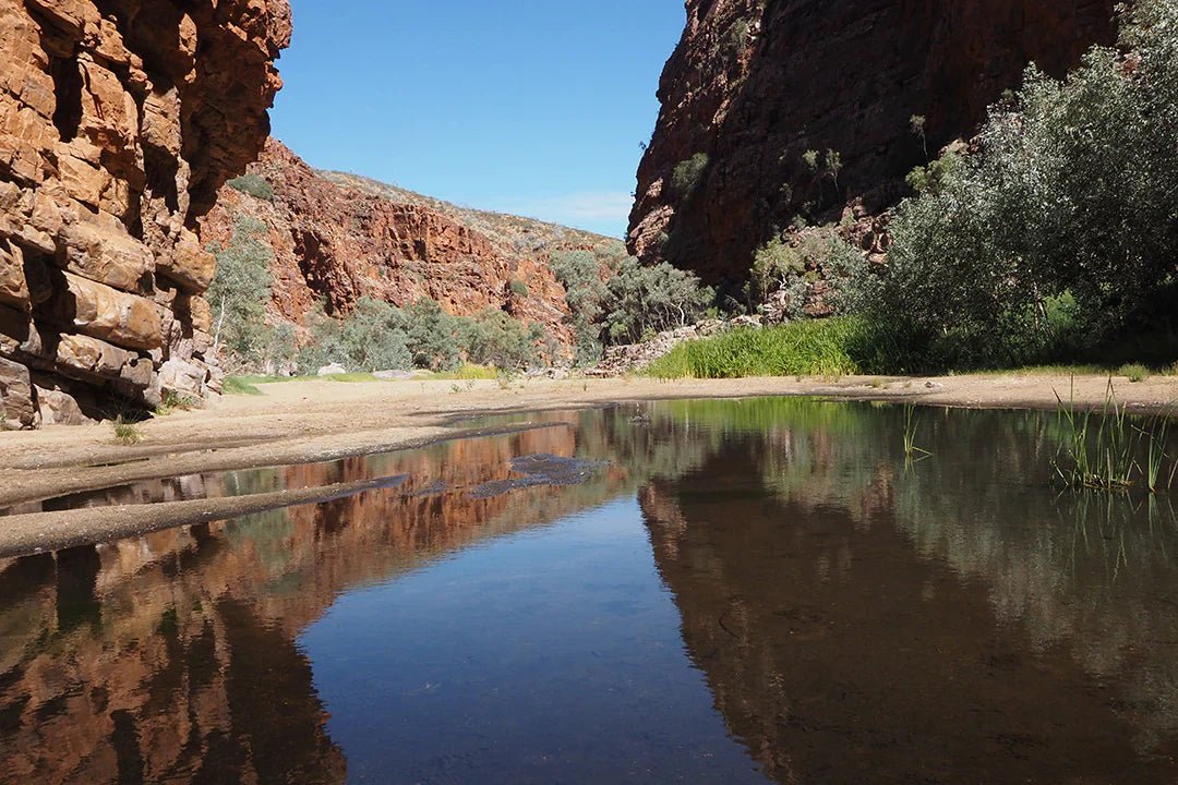
Ruby Gap Nature Park
Our next stop was Ruby Gap Nature Park, about 150km east of Alice Springs, where we had a tour organised with Bill Wilcox from Sandrifter Safaris.
Some places in the outback feel like they’ve been quietly tucked away, just waiting to be uncovered by travellers willing to make the effort — and this is one of those places.
Remote, rugged and wonderfully untamed, this corner of Central Australia sits on the wild fringe of the East MacDonnell Ranges. It’s also where the Northern Territory’s very first mining rush began in 1886.
The story begins with explorer, surveyor and mining entrepreneur David Lindsay. While travelling through the area in 1886 he picked up several red stones that he believed were rubies, sparking a rush of hopeful prospectors eager to stake their claim.
The excitement didn’t last long.
Those ‘rubies’ were later identified as garnets — attractive enough, but far less valuable. The rush faded quickly, yet the legend remained and the name Ruby Gap stuck.
Lindsay himself was no stranger to exploration. Earlier journeys had taken him across Arnhem Land and toward the Gulf of Carpentaria, and in 1891 he led the Elder Scientific Exploring Expedition across Australia’s interior. Although Ruby Gap didn’t bring the riches he expected, Lindsay later made a tidy profit from Western Australia’s Coolgardie gold rush. He also spent years promoting the state’s mining opportunities overseas and was involved in several pastoral and agricultural ventures in the Northern Territory.
These days, the rush to Ruby Gap looks a little different.
Instead of prospectors chasing gemstones, the visitors arriving here are bushwalkers, campers and four-wheel drivers drawn by something far rarer — solitude, towering red cliffs and desert waterholes that shimmer beneath endless blue skies.
The most common approach to Ruby Gap is via the Binns Track, turning off near Arltunga Historical Reserve. Be warned: this is serious 4WD country.
The final 38km into the park is slow and demanding, usually taking around 90 minutes in a properly equipped high-clearance 4WD. Expect rough tracks, sandy riverbeds and sections that feel as tough as the country around them.
From the park entrance, follow the Hale River — known in the Arrernte language as Lhere Altera — upstream.
Heavy rain can make the route impassable and flash flooding is a real risk. If rain has fallen upstream, don’t attempt to cross the riverbed.
And if you happen to be in it when water begins to rise? Get to high ground, fast.
In the hope that you don’t have to negotiate rapidly rising water, soon you’ll see the cliffs tighten around the riverbed, heralding that you have reached Ruby Gap itself. Keep an eye on the sand as you walk; garnets still sparkle here in the sunlight if you know where to look.
Step into the gorge and the colours immediately stand out.

Ruby Gap
Ochre cliffs rise above pale river sands, ghost gums shimmer in the heat and the sky overhead seems impossibly blue.
One of the highlights of the area is Glen Annie Gorge, about a 5km return walk from Ruby Gap.
Here the cliffs tower above a long waterhole that attracts an impressive array of birdlife. Australian reed-warblers call from the reeds, zebra finches dart through the trees and black-fronted dotterels patrol the edges. You may also spot Australasian grebes, painted finches and the ever-watchful bush stone-curlew.
On a hot Central Australian day, the waterhole becomes something else entirely, and a swim here feels like pure desert magic.
Another walk worth considering is the Fox’s Grave track, an 8km return hike from Ruby Gap via Glen Annie Gorge.
The grave belongs to F.H. Fox, a miner who in 1888 reportedly took his own life after discovering the rubies he’d hoped would make his fortune were nothing more than garnets. His lonely grave still sits on a small rise overlooking the valley.
It’s a sobering reminder of how harsh life could be during the early mining days.
Ruby Gap is the furthest point you’re allowed to drive.
Camping is permitted anywhere along the 5km stretch between the entrance and the gap.
There are no marked sites. Simply find a patch of flat sand along the Hale River beneath the ghost gums and roll out the swag or pitch a tent.
Facilities? None. There are no toilets, drinking water, bins or picnic tables. Nada. This is proper bush camping, which means you’ll need to bring everything you require and carry out everything you bring in.
Bookings must be made online before arriving. Fees currently sit at $4 per adult, $2 per child or $10 per family, and travellers from outside the Northern Territory will also need a Parks Pass.
At night the silence settles in.
Just the rustle of the wind through the gums, the crackle of the fire and the occasional sound of desert wildlife moving through the darkness.
Ruby Gap remains wonderfully untouched, so there are a few restrictions to protect the area.
Leave the following at home:
Pets
Generators
Drones (unless you have a permit)
Out here, preparation is everything. So, there are things you most definitely should bring, with essential gear including:
Satellite phone or personal locator beacon (PLB)
First aid kit
Sunscreen and sun-safe clothing
A second spare tyre
At least 8L of water per person per day (more if hiking)
A very wide-brimmed hat
Ruby Gap is the real deal.
You won’t find big crowds or soft-roaders here. Just red rock country, endless blue skies and layers of history stretching far beyond the brief European mining story of the 1880s. The Arrernte people have lived in this landscape for tens of thousands of years, and the geological history runs back hundreds of millions more.
The real reward is the quiet satisfaction that comes from visiting somewhere truly special — a place that still feels like the outback kept it secret just for you.
Arltunga Historical Reserve
Although the Ruby Gap rush fizzled out, the search for minerals didn’t end there.
Not long after, gold was discovered at nearby Paddy’s Rockhole and White Range, about 40km west of Ruby Gap and only a short drive from the Arltunga Bush Pub.
The new discovery sparked a much bigger rush.
Within a few years the small settlement of Arltunga had grown into Central Australia’s first substantial town. At its peak in the late 1890s, around 300 people lived and worked here.
Life was anything but easy.
Water was scarce, droughts were frequent and the work of hauling rock to the battery was brutally hard on both men and horses.
By the early 1900s the gold had largely run out and the population drifted away.
Today the remnants of that boomtown survive within Arltunga Historical Reserve. Visitors can wander through the restored buildings, explore mining equipment and learn more about the people who once chased fortunes here. The name ‘Arltunga’ comes from the Eastern Arrernte term ‘Arnerre-ntyenge’, which refers to a nearby waterhole.

Old Arltunga Ruins
The settlement emerged during the 1887 gold rush, when hundreds of determined miners travelled more than 600km from the Oodnadatta railhead, crossing harsh desert country in search of fortune.
Mining activity shaped the district for nearly 30 years. Today, remnants such as the Government Battery, Cyanide Works and the Old Police Station remain as reminders of the once-thriving goldfield. Restored stone structures, scattered ruins and interpretive displays allow visitors to explore the site and learn about both the mining technology and the challenges of life in this remote frontier community.
Arltunga Historical Reserve is open year-round, though the cooler months from April to September are the most comfortable for exploring. Road access can be affected by heavy rain, so checking conditions before departure is recommended.
Visitors will find picnic areas, toilets, barbecues and walking tracks connecting key historic locations. Fossicking isn’t permitted within the reserve itself, but a nearby designated area allows it with a permit.
Camping isn’t available within the reserve, although nearby options include Trephina Gorge, N’Dhala Gorge or the aforementioned Arltunga Bush Pub and Eco Retreat campground.
Declared a Historical Reserve in 1977, Arltunga today offers a fascinating look into the ambition and hardship of life on a remote desert goldfield — with more than 30km of surrounding 4WD tracks adding an extra layer of adventure.
Hale River Homestead
From Arltunga, the track continues north toward Hale River Homestead — an easy detour that offers a glimpse into life on a working cattle property.
The homestead sits within the 60sq km Old Ambalindum pastoral holding and has been transformed into a relaxed station stay where several historic buildings have found new life as guest accommodation.
The Cottage, dating from 1908, sleeps large families and features an impressive collection of local artwork and historical photographs.
Then there’s the Retro Van and Container, a quirky conversion of a 1970s caravan complete with vintage furnishings and memorabilia.
For campers, the property also offers a generous campground both with powered and unpowered sites, grassy areas and modern amenities including hot showers.
But the standout feature of Hale River Homestead is The Workshop,
Originally a Sidney Williams hut, the structure has been transformed into a welcoming bar and cafe. These prefabricated steel sheds by Sidney Williams and Company were widely used across Australia during the early and mid-20th century for agricultural and military purposes.
Today the hut houses an eclectic collection of vintage machinery and station gear.
Meals and drinks are served here, creating an atmospheric gathering space for travellers.
Hosts Lynne and Sean encourage visitors to slow down, explore the property and enjoy the walking and mountain-bike trails that wind through the surrounding hills.

Belinda at the bar, Hale River Homestead
Gemtree Roadhouse to Frew River 4WD Loop Road
From Hale River Homestead the Binns Track swings west, following Gardens Road before turning onto The Pinnacles Track.
This narrow route winds through rocky outcrops and wooded hills before eventually reaching the Plenty Highway and a well-earnt overnight stop at Gemtree Roadhouse and Caravan Park.
Gemtree is famous for its fossicking tours in the nearby Harts Range gem fields.
From Gemtree, follow the sealed Plenty Highway east past the small community of Atitjere, home to the vibrant Akngerrekenhe Art Centre.
Soon after, the Binns Track turns north onto Arapunya Road, a remote stretch of road that winds through open country for roughly 100km to Derry Downs.
Beyond here the terrain becomes more serious.
The road narrows into a genuine 4WD track, crossing sandy riverbeds and sections of rough, rocky ground.
Eventually the route meets the Sandover Highway, where you’ll turn northeast before continuing toward Murray Downs Road and the Hatches Creek Track.
The track snakes through arid hills scattered with sharp gibber stones and crosses numerous dry creek beds. It feels wonderfully remote.
It’s worth taking the detour onto the Frew River 4WD Loop Road.
The full 46km loop cuts through the heart of Iytwelepenty / Davenport Ranges National Park, traversing rugged ranges and dramatic landscapes. This track can be slow going, so make sure you’ve got plenty of time. It’s not a track you want to be embarking upon towards the end of the day. Nor is it a track you’d want to be dragging a camper trailer along.
Old Police Station Waterhole
Back on the Binns Track it’s only a short drive to Old Police Station Waterhole — one of the best campsites on the entire route.

Old Police Station Waterhole
Spacious camps sit along the banks of a long permanent lagoon on the Frew River, framed by red gums and rocky hills.
The site lies within Iytwelepenty / Davenport Ranges National Park, so entry fees and camping fees apply.
The police station itself was built in the 1920s to service nearby pastoral and mining activity. But those ventures never really flourished, and the station closed only a few years later.
From here the Binns Track joins a long transit section — around 140km west to the Stuart Highway, followed by roughly 440km north to Dunmarra Roadhouse.
There are a few worthwhile detours along the way.
Tennant Creek
At Tennant Creek, the Jabaljarri Arts and Merchandise centre offers a welcoming stop for self-contained travellers and features an excellent gallery. Owner Steve Jabaljarri Sutton is always keen to chat about his artwork and the rich Indigenous culture of the region.
At time of writing, Nyinkka Nyunyu Art & Culture Centre is temporarily closed however the upgrades are looking fabulous, and the centre is scheduled to reopen in late April 2026 marking a significant moment for the Warumungu people and the wider Barkly region.
After an extensive redevelopment, the refreshed centre will feature modern gallery, cultural and visitor spaces designed to better support local artists while strengthening Tennant Creek’s reputation as an important cultural destination in the Northern Territory.
The Northern Territory Government contributed $10 million to the project, ensuring Nyinkka Nyunyu can continue to celebrate Warumungu culture while helping grow the region’s creative and tourism sectors.
Nyinkka Nyunyu holds deep cultural importance for the Warumungu people and remains a key attraction within the Barkly. Through exhibitions, interpretation and community programs, the centre shares Warumungu stories, knowledge and artistic traditions. The redevelopment enhances these capabilities while improving facilities for artists, visitors and the local community.
The town of Tennant Creek itself has an interesting past.
A telegraph repeater station was built here in 1870 as part of the Overland Telegraph Line. Gold discoveries in 1926 transformed Tennant Creek into a bustling mining centre — an industry that continues today.
Visitors can explore both stories at the Telegraph Station Historical Reserve and the Battery Hill Mining Centre, which even offers underground mine tours.

Tennant Creek Telegraph Station Historical Reserve

Battery Hill Mining Centre
Dunmarra Roadhouse
Continuing north, the next major waypoint is Dunmarra Roadhouse near the junction with the Buchanan Highway.
Fill up with fuel here.
And whatever you do, don’t leave without trying the famous vanilla slice — often claimed to be the best in the Northern Territory — or one of the legendary meat pies.
Top Springs, Victoria River Downs and Bullita Homestead
From Dunmarra the Binns Track heads west along the Buchanan Highway, crossing wide cattle country.
The first major stop is Top Springs Hotel, a classic outback pub at the junction of the Buchanan and Buntine highways.
Cattle dominate this landscape. The fertile basalt soils support vast pastures of Mitchell and blue grasses, ideal for grazing.

Top Springs Hotel
Soon after leaving Top Springs you will pass the enormous Victoria River Downs Station.
Once the largest pastoral lease in the world, the property is still immense. Today it comprises five stations covering roughly 2700 sq km and running more than 100,000 Brahman cattle.
From here the Binns Track follows the Humbert Track, a rugged 4WD route running between Bullita and Humbert River stations. Humbert Track is definitely no place for caravans or camper trailers. (If you’re towing an offroad caravan or offroad camper trailer, you’ll need to stick with the Buchanan Highway to the Victoria Highway).
Bullita Homestead itself was built in 1960 as an outstation of Humbert River Station, replacing an earlier homestead destroyed by fire.
The property includes several outbuildings and a large timber cattle yard, along with a campground for travellers exploring the park.

End of the Binns Track
Just like Old Andado Station at the southern end of the route (which we visited in part one), Bullita Homestead provides a powerful sense of the Territory’s pastoral history.
Together, Old Andado and Bullita form fitting bookends to the Binns Track adventure.
From Bullita the final section of the Binns Track runs north and then west along the Victoria Highway, eventually finishing in Timber Creek on the banks of the Victoria River.
The Binns Track isn’t ‘just another’ scenic drive through the outback.
It’s a 2230km journey across the spine of the Northern Territory, stretching from the arid edge of the Simpson Desert to the limestone plains and savannah country of the Top End.
The route reflects Bill Binns’ vision of a track that avoids crowded tourist hubs in favour of authentic outback experiences.
But it’s not a journey to take lightly.
Isolation is real out here. Conditions can shift quickly — from bulldust and corrugations to rocky escarpments and sandy river crossings.
Preparation is essential.
A high-clearance 4WD, dual spare tyres, recovery gear and reliable communications should all be considered mandatory.
For travellers willing to plan properly, however, the reward is extraordinary.
Few routes offer such a complete cross-section of the Northern Territory — its landscapes, its history and its enduring outback spirit.
Maps so you don’t get lost
Binns Track 4WD Adventure Guide (Westprint Outback Maps Published by Meridian Maps)
Related articles
Binns Track, Northern Territory — Part one
Offroad sightseeing within coo-ee (200km) of Alice Springs


