


Words Julija Zivanovic and Hema Maps Editorial Pics Supplied
Our Hema Map Patrol Team and wider NSW staff voted these as their five favourite four-wheel drive tracks across New South Wales. Keep reading to learn more.

New South Wales was certainly blessed by Mother Nature, boasting incredible natural attractions. From the Blue Mountains and expansive national parks to the Kiama Blowhole and everything in between, NSW is a paradise for the 4WD enthusiast. Whether you’re on a multiweek tour or have just managed to escape for a long weekend, there are plenty of NSW tracks for the taking — both challenging and easy going.
We went on a mission to discover the top five four-wheel drive tracks in New South Wales and what better way than to turn to our team of experts and NSW residents. It wasn’t easy picking five, and after extensive voting from the Hema Map Patrol, Hema Alpha Team and even some keen staff who know and love the area, we managed to narrow it down to the top five.
Keep reading to learn more about each of the tracks — including time, distance, warnings, permits and fees — which will hopefully inspire your next adventure!

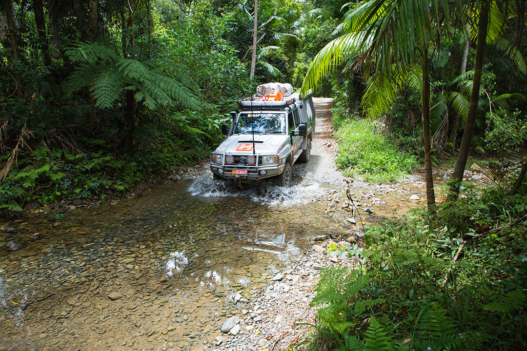
1. Barrington Tops
The beautiful drive within World Heritage-listed Barrington Tops National Park was the unanimous winner, and for good reason. This introduction to the Gloucester and Barrington area begins with a visit to the tallest known tree in New South Wales: ‘The Grandis’. This flooded gum (Eucalyptus grandis) is about 400 years old and is more than 76m high. The first branch on its white trunk is 25m from the ground (about seven storeys) so it’s truly humbling to stand beneath this forest giant that was a seedling when the British were busy sinking the Spanish Armada.
From Bulahdelah head north for 4km on the A1 to Wooton Way (Old Pacific Highway). After 5km turn east onto the gravel Stoney Creek Road and drive 6km to ‘The Grandis’. From here, our trip takes in little-travelled forest tracks that parallel a long-disused forest railway line that was once used for log transport. Retrace your way back to Wooton Way, turn north and drive 12km to the township of Wootton then turn west onto Squires Road. Keep left after 1.5km and continue for 3km, then keep right onto Bangalow Road. From here, continue straight ahead onto Worths Creek Road where you can find the Wootton Historical Railway Walk.
To continue reading about this track, grab a copy of 4WD Adventures and turn to page 55. Otherwise, continue on to the track’s essential information below.

Track details
Grading: All-wheel drive (AWD)
Time: Day trip or overnight in Gloucester
Distance: 306km, Bulahdelah to Scone
Longest distance without fuel: 122km, Barrington to Gundy
Best time of year: Spring or summer but be prepared for sudden weather changes at any time of the year. It can snow in winter.
Warnings: Four-wheel drive trails in Barrington Tops NP are closed annually to vehicles in the winter months, usually 1 June to 30 September. There is risk of ice and snow in early spring and late autumn. There are steep grades into Moonan Flat, and touring isn’t recommended on the Wang Wauk Forest Way.
Permits and fees: Camping fees apply
Activities: Lookout platforms, bushwalking, picnicking, camping, mountain biking, swimming, canoeing, rafting, fishing
2. Coffs Harbour Hinterland
This picturesque trip begins in Sawtell, which threatens to swallow your motivation before you even leave reach escape velocity! It’s low-key but far from ramshackle, and with an effortless coffee culture brewing along its main esplanade — it’s what Byron Bay was before capitalism took notice at the turn of the millennium.
Head north out of town along Hogbin Drive, then west along Stadium Drive towards Boambee State Forest. Englands Road becomes unsealed as you begin to climb the hills around the North Boambee Valley, before it turns into Gum Flat Road and the track becomes more interesting — a change that’s perfect timing with the increase in elevation. The lower sections at the edge of the forest are easily flooded, and when dry they can present some challenging ruts and washouts.
After exiting the forest, head west along the sealed arterial road taking in the quaint Upper Orara countryside before you plunge into the overgrown masterpiece of Bindarri National Park.
To continue reading about this track, grab a copy of 4WD Adventures and turn to page 74. Otherwise, continue onto the track’s essential information below.

Track details
Grading: 4WD, Medium
Time: Overnight
Distance: 190km, Sawtell to Woolgoolga
Longest distance without fuel: 69km, Nana Glen and Woolgoolga
Best time of year: All year round — although in winter, temperatures can become bracing.
Warnings: Recovery gear is essential in or after wet weather, especially in state forests.
Permits and fees: National park camping fees apply.
Activities: Bangalore Falls, swimming, bushwalking, camping, birdwatching
3. Myall Lakes
Just two hours north of Newcastle by car, this spectacular overnight drive is pretty easy going for the most part and takes you through multiple terrains over 141km. The drive through the northern section of Myall Lakes National Park includes the oceanfront, with beach driving access at Seal Rocks and the lakeside picnic and camping area at Violet Hill. Remember to always lower your tyre pressures before driving onto the beach.
From the town of Bulahdelah head north on the Pacific Highway then take the Lakes Way to Bungwahl and turn right towards Seal Rocks. The 10km road to Seal Rocks is bitumen, with some blind crests and tight corners. After about 2.5km along the road turn right for a visit to Neranie Campground with its choice of lakeside or bush campsites.
Continue to Seal Rocks where there is a modern campground just across the road from the beach. Beach driving is permitted on this short stretch of sand, but camping isn’t allowed. Follow the road to Sugarloaf Point Lighthouse car park for a short walk to the historic lighthouse for stunning views of the coastline both north and south. A longer stretch of beach driving is on the ocean front at Lighthouse Beach.
To continue reading about this track, grab a copy of 4WD Adventures and turn to page 63. Otherwise, continue onto the track’s essential information below.

Track details
Grading: AWD
Time: Overnight
Distance: 141km, Bulahdelah to Hawks Nest (plus beach driving distances)
Longest distance without fuel: 43km, Bulahdelah to Hawks Nest
Best time of year: All year round — although it is wise to avoid school holidays if possible.
Warnings: Narrow beach access tracks. Tidal chart essential for safe beach driving as these are unpatrolled beaches.
Permits and fees: Park entry and camping fees apply. Fees apply (cash only) for the Bombah Point ferry and beach driving permits are required.
Activities: Kayaking, birdwatching, camping, beach driving, swimming, fishing, surfing, bushwalking, whale watching
4. Stockton Beach
Stockton Beach is the largest mobile sand mass in New South Wales, with the dunes moving northwards by about 4m each year, smothering the trees and vegetation that fringe the beach. Unlike most sand stretches, Stockton has variable consistency; some hilltop regions are as soft as the windblown hollow ‘traps’ and the sand can change from hard to soft to hard in a matter of metres without any surface indications. There are two places to enter the beach — Gan Gan Road in the north or Lavis Lane to the south. Remember to always lower your tyre pressures before driving onto the beach and never drive on vegetation.
Our drive heads to the beach via Lavis Lane — off Nelson Bay Road between Stockton and Williamtown. Drive 3km then turn right at the well-signposted Worimi Conservation Lands (4WD access and car park). Two-wheel drive vehicles can safely continue as far as the car park and tyre deflation area on the gravel road. Four-wheel drives follow the access track out to the beach.
On the southern side of the access track, beach and sand dune access is permitted for 4WDs and approved recreational vehicles. Driving on the sand dunes (unvegetated) is permitted for about 3.5km south — as indicated by signage and fenced ‘no-go’ areas. The back dunes (driving area south of the Lavis Lane entry point) are a mixed bunch — some are low and gently sloped and others are high and very steep, particularly on the northern faces.
To continue reading about this track, grab a copy of 4WD Adventures and turn to page 61. Otherwise, continue onto the track’s essential information below.
 Stockton Beach (Credit: Adobe Stock Images)
Track details
Grading: 4WD, Medium
Time: One day
Distance: 78km, Stockton return
Longest distance without fuel: 55km, Stockton to Anna Bay
Best time of year: All year round
Warnings: No trailers are permitted to enter Fern Bay. Be aware that fuel consumption is very heavy in soft sand, steep dunes and beachfront. Always carry a tide chart. Be aware and take care: on the Worimi Conservation Lands, visitors may find an unexploded ordnance from WWII defence training — do not touch, call 000.
Permits and fees: Stockton Beach is jointly managed by NPWS and the Worimi Conservation Lands Board. Two types of vehicle permits are available for here: a Vehicle Permit for 4WDs and a Recreational Vehicle Permit (ATVs, etc.). Three-day or annual permits are available.
Activities: Beach driving, WWII history, swimming, sandboarding, quad biking, camel and horse riding, fishing, camping
5. Watagans
About 99km north of Sydney, the Watagans is a striking mountain range that is part of the Great Dividing Range. The rich wilderness in the area makes for an exciting day trip through this unique part of the state, with the drive being mostly mellow. Our suggested tour through the Watagans can be done comfortably in dry weather by a soft roader. The starting point for this drive is the little town of Kulnura, but the Watagans are also easily accessible from Cooranbong or Cessnock.
There is an oddly named turnoff — The Letter A — 12km north of Kulnura. Turn north here onto the gravel Walkers Ridge Forest Road and stay right after 2km. After a short distance turn left and then a further 4km along the track, a left turn will take you the Basin camping area and a right turn will continue the drive on Walkers Ridge Forest Road.
Olney Headquarters camping area is 4km further along the track. Turn right here onto Watagans Forest Road and turn right again after 3.5km to continue on the same road. Drive 1km then turn left onto Prickly Ridge Road which leads directly to Muirs Lookout car park.
To continue reading about this track, grab a copy of 4WD Adventures and turn to page 59. Otherwise, continue onto the track’s essential information below.

Track details
Grading: AWD
Time: Day trip or overnight
Distance: 84km, Kulnura to Gap Creek camping area
Longest distance without fuel: 128km, Gosford to Cessnock
Best time of year: All year, except when areas are closed in periods of extreme fire danger or continual wet weather. Winter camping can be freezing.
Warnings: Trail bikes share the roads in the state forest and may enter off side tracks without warning. In the state forest part of the Watagans log trucks are common, even on weekends, so keep a sharp eye out for them and take particular care when rounding blind corners.
Permits and fees: No park entry or camping fees apply.
Activities: Mountain biking, picnicking, waterfalls and rock holes, bushwalking, camping, abseiling
4WD Adventures

Most of the information from this article was taken from the Hema 2nd Edition 4WD Adventures guidebook which covers Australia’s TOP 100 four-wheel drive trips, segmented according to state/territory and region. Covering 19 Australian regions with detailed inset maps, this is the perfect companion for Aussie four-wheel drivers. If you would like to purchase a copy of 4WD Adventures, simply head to the Hema Maps website or visit our retail partners.
Related articles
Choosing the best 4WD recovery gear
Free and budget campsites: New South Wales
Outback New South Wales — 5 popular summer destinations you can’t miss


