


Words Robert Crack and Amelia Mansell Pics Sean Scott Photography
Taking a road trip from red rock to coral reef along the Gascoyne River is a unique experience. It invites travellers to follow the path of this ancient waterway and discover one of Western Australia’s most rewarding touring routes.

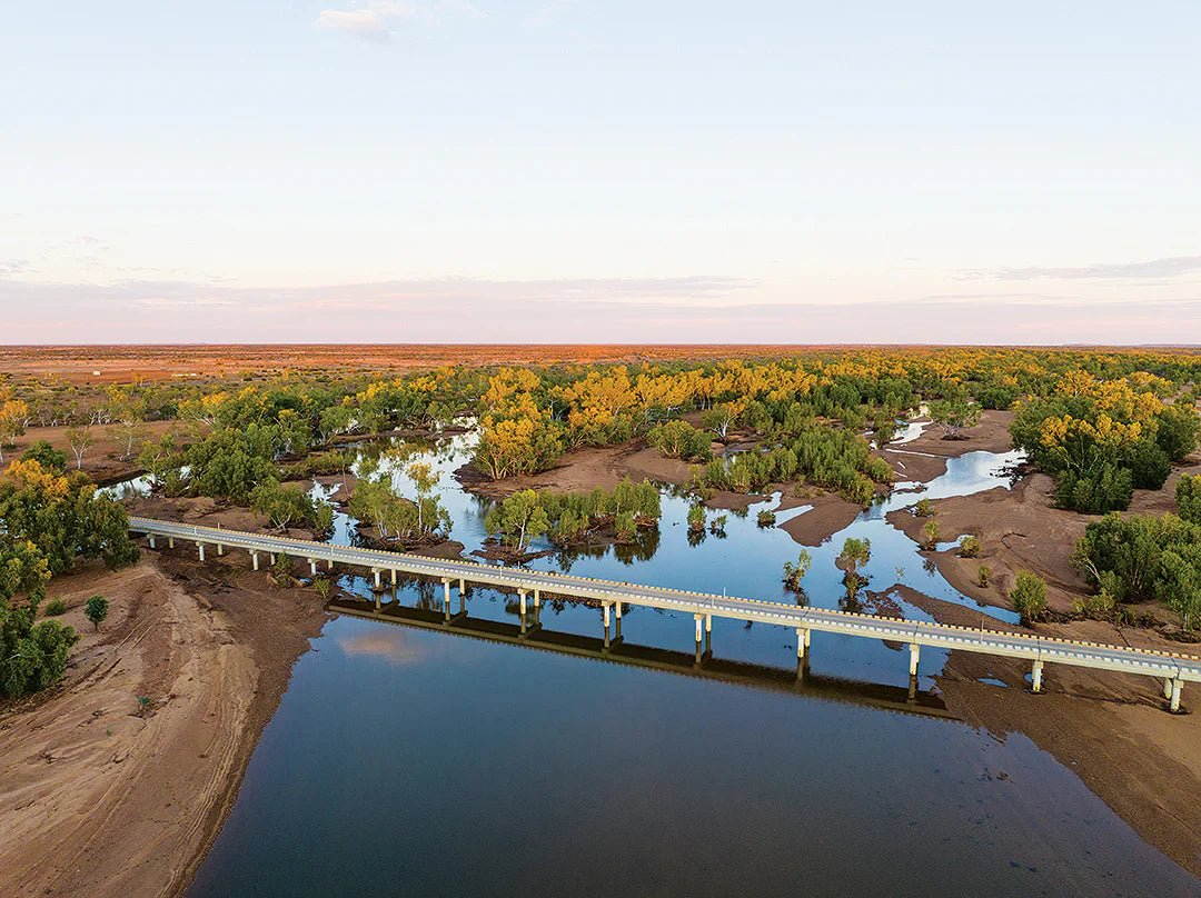
The Killili Bridge and Gascoyne River at Gascoyne Junction.
Follow the path of WA’s Gascoyne River and you’ll discover one of the state’s most rewarding touring routes — a journey that runs from red rock ranges to turquoise reef. It’s one of the only places in Australia where you can tick off outback stations, heritage towns and world-class snorkelling in a single trip.
This isn’t just a drive. It’s a full-blown adventure: deep gorges, coastal cliffs, stargazing skies, fresh tropical fruit and station stays that serve up genuine outback hospitality.
Ancient tracks and modern tales
Long before settlers arrived, the region’s Traditional Owners followed the Gascoyne’s seasonal flow between inland waterholes and the coast. That connection lives on through cultural tours and centres dedicated to sharing stories of Country.
Pastoral life began in the 1870s with stations fed by bore water. In the 1920s, aviation legend Charles Kingsford Smith ran his outback mail route from Carnarvon to Meekatharra — funding flying dreams by hauling letters and parcels across the desert.
Carnarvon’s deep-water port soon shipped out wool and beef, then tropical fruit — a tradition that still defines the region today.
Gateway to the outback: Gascoyne Junction
Depending on where you’re travelling from, there are plenty of ways to experience the Upper Gascoyne region, but following the natural path of the river is one of the best ways to see every side of this multi-faceted corner of Australia. If you’re beginning your journey inland, Gascoyne Junction is the best spot to kick off your road trip.
Gascoyne Junction is the Upper Gascoyne hub, where the Lyons and Gascoyne rivers meet, 176km from Carnarvon. The Gascoyne Junction Pub & Tourist Park is the place for a feed, yarn with locals and a comfy base camp to explore nearby parks.
The town is tidy too. In fact, it took out the 2023 National Keep Australia Beautiful Tidy Town Award.
But don’t let the neat streets fool you — this is still cattle country. Since the 1980s, cows have ruled the roads, so keep an eye out on your way through.
Some must-visit local attractions are the Gascoyne Junction Historical Museum, where you can find out more about life along the Gascoyne River and how it impacted the pastoral community, and Gwoonwardu Mia – Gascoyne Aboriginal Heritage Cultural Centre, which showcases the region’s Aboriginal heritage and its five language groups.
Heading further afield, Kennedy Range National Park is under an hour drive away and boasts honeycombed cliffs, bush camping at Temple Gorge Campground. It’s also one of the best stargazing spots in WA, so if you’ve got the time, we recommend camping out for at least a night.

Temple Gorge Campground, Kennedy Range National Park
Think Uluru is huge? Meet Mount Augustus — the world’s largest rock, twice the size and 8km long. Sitting 300km northeast of Gascoyne Junction, it’s a giant slice of outback WA. You’ll find rocky creeks, aboriginal rock art and walking trails that range from easy to the 12km Summit Trail (open March to October). To see the area like the locals do, camp under the giant rock at Mount Augustus Tourist Park, which is part of the WA Station Stay network.
Once you’ve ticked Gascoyne Junction, Kennedy Range and Mount Augustus off your list, keep following the river towards the coast. Along the way you’ll strike shady waterholes such as Rocky Pool before rolling into Carnarvon, where the Gascoyne River flows into the Indian Ocean and where the outback meets the coast.

Welcome to Gascoyne Junction

Cattle Pool, Lyons River, Mount Augustus National Park
Carnarvon
This coastal town is famous for its tropical produce, relaxed vibe and mix of history and culture. Enjoy a coffee overlooking One Mile Jetty and walk along the fascine to enjoy park and waterfront views. Afterwards, head over to the Carnarvon Space and Technology Museum which showcases Carnarvon’s unique role in Australia’s space tracking history thanks to its clear skies and remote location.
The quirky Cactus Garden is another must-visit; this garden began more than 15 years ago with a few gifted cacti and has grown into one of the area’s most popular spots for photos.
The Carnarvon Growers Market is held every Saturday morning and is a great place to get fresh fruit and vegetables straight from local farmers.
Carnarvon is also home to the HMAS Sydney II Walk Trail, a memorial trail that commemorates the sinking of the Australian warship HMAS Sydney (II)in 1941, and the tragic loss of all 645 crew members.
Following the coastline
After you’ve soaked up everything Carnarvon has to offer, the coastline offers two road trip opportunities.
Head north and you’ll reach Coral Bay, Ningaloo Reef and the Quobba Coast with its famous Quobba Blowholes, limestone cliffs and great short fishing on Point Quobba. This region is coastal paradise, with campsites just metres from the water and plenty of snorkelling opportunities. And for a station stay with a difference, check out Warroora Station along the Ningaloo Reef with beachfront camping.
The other option is to travel south to set up camp at Wooramel Station with its beautiful campground on the banks of the Wooramel River (a Gascoyne River tributary), artesian bore baths and plenty more.
Tracks and trails for every traveller
Kingsford Smith Mail Run — This 834km drive follows an old mail route from Carnarvon to Meekatharra via Gascoyne Junction, Kennedy Range and Mount Augustus. There are interpretive signs along the way that tell stories about both European history and the Dreamtime.
Mount Augustus Scenic Loop — A 50km self-drive showcasing natural beauty and station life.
Kennedy Loop Track — A rugged 1.5-day 4WD run through the remote western side of the Kennedy Range. range. It’s for experienced four-wheel drivers only and if you are towing a camper or caravan, you need to unhitch and leave it behind.
Outback Pathways — three self-drive trails through central WA with interpretive signage that offers insights into the region’s landscape and stories. These are self-drive routes offered by the Gascoyne Murchison Outback Pathways.
Learn more with a guided tour
Join Wooramulla Eco Cultural Journeys for guided experiences:
Dawson’s Burrowing Bee Tours (see the giant Moogadgurrah bee in season)
Night sky walks
Bush tucker and storytelling tours
When to go
Best season: April–September (mild days, cool nights).
Avoid: Summer inland — temps often top 40°C.
Closures: Mount Augustus Summit Trail shuts November–February.
Bonus: July–September brings wildflowers, bees and local events.
Where to stay
There are many options along the Gascoyne route for all types of travellers — from well-equipped caravan parks to off-grid station stays and campgrounds.
Most station stays are part of the WA Station Stay program, offering everything from beachfront camping to off-grid inland bases. Options run from powered sites to shearers’ quarters and homestead rooms — all with a warm welcome.
A four-wheel drive is useful for some of the tracks, but most roads, including those to Kennedy Range and Mount Augustus, are suitable for other vehicles. Always check road conditions before you go. For up-to-date road conditions, visit the shire website here.
And don’t forget your camera — the sunrises, stars and mix of outback and coastal scenery are some of the most beautiful in the country.
- Capricorn Holiday Park
- Carnarvon Caravan Park
- Coral Coast Tourist Park
- Discovery Parks Carnarvon
- Gascoyne Junction Pub & Tourist Park
- Mount Augustus Tourist Park
- Outback Oasis Caravan Park
- Plantation Caravan Park - Carnarvon
Temple Gorge Campground (DBCA) — Peaceful Kennedy Range site, small fee but bookings are not required. For more information, click here.
Blowholes, Point Quobba Campground — You’ll need a chemical toilet to be permitted to camp here as there are only dump point facilities and no toilets, water or shade. Day pass is $10 per vehicle and camping fee is $30 per vehicle per night (maximum six people). Click here for more information.
Gladstone Bay Campground — You’ll need a chemical toilet here, too, in order to be allowed to camp here. There are no toilets, no dump facilities, no shade and no water. Day pass is $7 per vehicle and camping fee is $13 per adult and $5 per child (over eight years old) per night. Click here for more information.
Station stays: Wooramel River Retreat, Warroora Station, Quobba Station and Bullara Station.
Let the Gascoyne guide you
The beauty of this journey is in its pace. Let the Gascoyne shape your route from the rugged inland ranges to the famous turquoise waters of the WA coast. Whether you're looking for outback solitude or coastal views, the Gascoyne will take you there — and bring you back again.
Return for part two
We’re not finished yet with these remote and rugged beautiful regions of Western Australia! Come back soon for part two.
Maps
Mid West Western Australia Map
Western Australia Road & 4WD Track Atlas


