


Words David Priddis Pics Supplied
Join David Priddis from Australian Overland as he explores Wilsons Promontory — a dream location for nature enthusiasts. David has travelled around Australia to experience the country’s greatest offroad destinations, and the iconic Wilsons Prom in Victoria does not disappoint.
 The famous Wilsons Promontory Lightstation (Credit: Heather Rose)
The southernmost point of mainland Australia lies within Wilsons Promontory National Park, and its scenic tracks, pristine beaches and rugged coastline have made it a longtime playground of Melburnians and visitors from far and wide. Most folk either come to complete the multi-day coastal hike or to visit the Wilsons Promontory Lightstation at the southeast point. For some reason, however, the idea of hiking to reach the southernmost point is not on the agenda for most — which made the trek all the more exciting.
The closest point you can drive to is the Telegraph Saddle car park. From there it’s a 13km hike, following the dirt road, to the closest campsite to the southern point called Roaring Meg. There you can set up camp and complete the further 8km round trip to the point unencumbered by your heavy pack. The dirt road is well graded and could also be cycled, meaning you could turn the trek into a quick ride if you were so inclined.
Essential gear
The trip
The dirt road at first takes a winding path to the valley floor in the comfortable shade of tall pine trees. As you arrive at the valley floor, the vegetation thins out and it can be a hot, stuffy hike through the lowlands in the direct sun, starved of the sea breeze by the surrounding hills. Once at the southern side, it’s a steady climb past Halfway Hut, which is worth a look, and onto the summit. On the steady hike up, be sure to turn around and enjoy the panoramic view back along the valley and down to the ocean; lush green vegetation stretching to the deep blue sea, separated by a thin ribbon of golden sand.
Once over the top of the pass you follow the dirt road on a gradual descent to Roaring Meg Campsite, which is in the shade of tall trees. The first sign that indicates you have arrived is the wooden dunny on the corner, which you walk past to enter the camping area. There you will find a range of cleared flat areas to choose from, though this time I chose to follow the trail down to the left, which takes you to Roaring Meg Creek itself. There you can find secluded camping spots all along the creek that give easy access to freshwater for cooking and cleaning, and where I set up camp and left the majority of my gear.
If you plan on leaving your food behind, be sure to hang it high in a tree. If you don’t, wombats may come clawing at your tent to get at what’s inside, which is obviously more of a concern at night, but it never hurts to take precautions.

Now, just carrying my phone and water bottle, I returned to the higher area of the campsite to find where the trail for the southern point left. Unhelpfully, the sign had disappeared (it may be back by now) and the starting point of the track south was not very obvious. At the time of my hike, it was not until you are on top of it that you are sure that you’re on the right path. Following the trail through the forest along the hillside, you get the impression it doesn't see a lot of traffic: lack of erosion and sections of rough trail gave me an indication that few bother to seek out this corner of the great continent. When compared to the hordes that tramp the short walk to the tip of Cape York, you feel this is a real adventure.
As you descend the trail to the coast, the trees start to clear and the stunning beauty of the ocean crashing into the rocky shore is laid out before you. Upon stepping onto the point itself, you find the long sought-out sign confirming your hike has not been in vain and you have indeed arrived at the southernmost point of the Australian mainland. In comparison to the other signs that I have encountered marking the other extremes of the great island, this one is humble: a simple printed sheet of paper covered in Perspex and bordered in a wooden frame. But there is more land beyond the sign and not wanting to fall short of the actual southernmost point, I scrambled my way along the rocky point to where it actually meets the ocean.

The weather is perfect and the blue Tasman Sea crashing against the massive granite boulders in loud waves of sound truly make you feel you have reached somewhere special. If you look carefully around, you will find a wooden stump of a previous South Point sign that has succumbed to the power of the ocean. After taking an obligatory selfie with the sign and sitting for a while to just absorb the view, it was time for the hike back to camp.
As I caught sight of my tent, I looked at my phone to discover I had walked 21km for the day. The tiredness in my legs then felt justified and I decided it was time for a good feed. Later that evening, falling asleep to the sounds of water trickling through the creek, I drifted off satisfied with the day’s events and happy to have reached yet another of Australia’s remote points.
Information
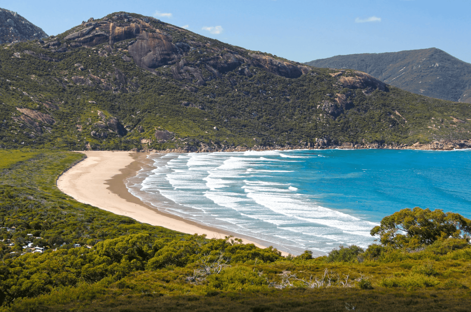
 The iconic Squeaky Beach in Wilsons Prom won Australia's best beach in 2023 (Credit: Zac Porter)
Camping:
Tidal River Campground is fairly priced for up to eight people (free at the moment until 30 June 2025), but you need to book ahead. A camping permit includes free parking at Telegraph Saddle car park, the closest place to the southernmost point you can park your car. There's a general store nearby to pick up any necessities or food you need.
Roaring Meg Camping Area is 8km return from the southernmost point and has a drop toilet and natural water source at the campsite (although it's recommended you treat the water before consuming).
Nearby attractions:
Located conveniently close to Tidal River Campground, Squeaky Beach was named Australia's Best Beach in 2023 and is well worth a visit. Enjoy a coastal walk along the beach and see just how squeaky this beach actually is! Norman Beach is another great option for swimming, kayaking and standup paddleboarding. Or head over to Oberon Bay Walking Track which offers panoramic views over the surrounding area and Little Oberon Bay.
And while you're on the southern circuit, don't miss the historic Wilsons Promontory Lightstation.
 (Credit: Chris Gordon)
Boat tours are one of the best ways to see the local wildlife, including Australian fur seals, humpback and southern right whales, dolphins and more. These tours offer fantastic views of the offshore islands, featuring remote beaches, towering cliffs and rolling forests.
Further assistance:
Tidal River Visitor Information Centre
1 Ring Road
Tidal River Vic 3960
Open daily from 9am to 4pm
P: 03 8427 2122
Or head to Parks Victoria for more inspiration and to book a spot at a campground, which can book out quickly in peak seasons (the summer months especially).
We would also like to remind you that Parks Victoria is offering free camping in 131 of its bookable campgrounds until 30 June 2025. Book now to take advantage of this fantastic offer.
Related articles
Free and budget campsites: Victoria
Top 10 places to visit in the Victorian High Country
Tips for family 4WD touring on a budget


