
Your guide to the Anne Beadell Highway, WA
Words Hema Maps Editorial Pics Matt Williams
The Anne Beadell Highway, located in Western Australia, is a track carved through some of the most isolated and harsh areas in Australia.
Travel update from Ilkurlka Roadhouse (23 May 2024)
The Anne Beadell Highway remains closed because of the abnormal March rainfall. An inspection this week found up to a metre of water still over some sections of the track. The next shire update will be on 12 June 2024, but until then, the Anne Beadell Highway will remain closed. Please check Laverton and Kalgoorlie-Boulder Shire road reports for road closures.

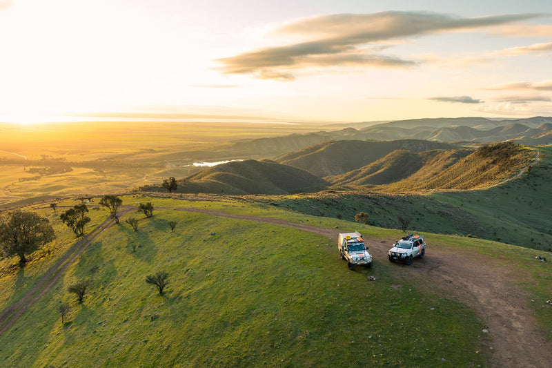
Start and end of Morton Craig Range
Essential information
Grading: Low range and high ground clearance
Time: Minimum seven days
Distance: 1375km, Laverton to Coober Pedy
Longest drive without fuel: 779km, Ilkurlka Roadhouse to Coober Pedy
Facilities: Laverton, Ilkurlka Roadhouse, Coober Pedy
Best time of year: May to September: avoid summer months as temperatures are extremely high. Remember that in other seasons, night temperatures can drop below freezing, so you will need a decent sleeping bag.
Warnings: This is an extremely remote track. Unless you are a very experienced desert traveller, solo travel is not recommended. Prepare your vehicle well — carry necessary fuel, take the right communications such as a satellite phone — with more than adequate food and water, and a sensible selection of spares, including two spare tyres. Put a red flag on your aerial and use your UHF to alert other possible traffic to your presence. You should also consider a registered EPIRB. Alcohol restrictions apply on Aboriginal land.
Permits and fees: These days you require a number of permits to traverse the Anne Beadell Highway, depending on what you want to do. You don't need a Desert Parks Pass to camp at Mamungari Conservation Park, but you'll need a camping permit. You'll also need a permit from Maralinga Tjarutja Incorporated. A Desert Parks Pass and camping permit are required for Tallaringa Conservation Park. You'll also need a permit from the Defence Support Centre for the Woomera Prohibited Area.
Important contacts:
● Ilkurlka Roadhouse
Ph 08 9037 1147
● Tjuntjuntjara Community
Ph 08 9037 1100
● The Great Beyond Visitor Centre Laverton
Ph 08 9031 1361
● Coober Pedy Visitor Centre
Ph 08 8672 4617

Neale Junction Nature Reserve
The track was the creation of surveyor Len Beadell, who then named his work after his wife Anne, and extends a length of about 1375km. This track is definitely not for newbies – it takes a certain level of skill to navigate, and self-sufficiency is of the utmost importance. With that being said, the track is an extremely popular destination for the more adventurous 4WD enthusiasts.
The Anne Beadell Highway starts in Laverton, Western Australia, and takes travellers all the way to Coober Pedy, which is situated in South Australia. Along the way, travellers will get an up-close-and-personal view of what draws people to some of the most remote areas of this country. Throughout the journey, see the landscape slowly altering from clay pans to the breathtaking red sand dunes.
The Yeo Homestead
The Yeo Homestead camping area gives visitors the chance to rest but it is important that travellers take note that this area only offers basic provisions, which includes toilets, drinking water and camping grounds. The grounds are situated about 213km northeast of Laverton.
Ilkurlka Roadhouse
The Ilkurlka Roadhouse is the sole roadhouse along the Anne Beadell Highway between Laverton and Coober Pedy. The establishment is located about 700km northeast of Kalgoorlie and offers visitors toilets, a barbecue area, a hot shower and a self-contained studio accommodation. Currently, the roadhouse is considered to be one of the most remote roadhouses in the country and generally caters to the Aboriginal population in the area.

Ilkurlka Roadhouse
The Mamungari Conservation Park
The Mamungari Conservation Park is an area of protected land that did not receive a name until 2006. It has been named one of a total of 14 world Biosphere Reserves within the country and it is still managed, in part, by its Traditional Owners. Permits are required in order to travel through this area.
Preparing for the Track
Anyone looking to venture out onto the Anne Beadell Highway will need to prepare for the length of the journey, owing to the limited supplies available along the way. Only high clearance 4WD vehicles will be able to access the entirety of the track and permits are required to allow visitors to pass through both Aboriginal and private lands. There are few signposts on the track, which means that 4WD enthusiasts will need to bring along maps and additional guides. Weather conditions, such as flash floods, can add to the potential hazards faced on the journey.
Points of Interest
Some places that visitors will want to look out for include Emu Field, which is the area formerly used by the British for nuclear weapons tests. A light aircraft wreck can be viewed along the way, as well as Mamungari Conservation Park, which is based in South Australia. The Anne Beadell Highway is currently one of the only main roads that passes directly through this conservation park.
The Anne Beadell Highway is a good reminder to travellers of what makes Australia such an appealing destination for 4WD enthusiasts, and it is one that will continue to challenge experienced 4WDers for many years to come.

Spinifex grass rings along the track
Next steps
At Hema Maps, we strive to provide the most comprehensive and accurate maps and guides for outdoor enthusiasts looking to explore Australia's natural wonders.
Did you find this information useful? If so, please share it with your fellow explorers. Whether it's by SMS, social media, or email, your friends and fellow adventurers will appreciate the valuable tips and insights we've shared.
Let's work together to make the most of every adventure.
1 comment


Be doing it in May 25 done Simpson, Canning up for this challenge
Captain Billy 4WD Cairns