


I love maps and I love explorers so when I recently discovered an online treasure trove of explorer’s maps, I felt like I’d been given the keys to a Spanish galleon’s treasure chest, just hauled from the deep.
Australia’s intrepid explorers had no idea that centuries later their painstaking surveying and cartographic work would be available in digital form to download, print or order online. But with 362,000 maps to explore via the National Library ‘Trove’ archive you could spend the next century viewing them all.
These are my six favourite maps, at least from those I’ve discovered so far:
KEULEN 1697 The South Lands discovered by Willem de Vlaming (dutch translation):

On 25th October 1616, Dirk Hartog came across Australia’s west coast and mapped a small section of the coastline before continuing north to Indonesia. He left a pewter plate at Cape Inscription on Dirk Hartog Island, a site you can still visit by 4wd today. By 1644 the Dutch had mapped most of Australia’s north and west, including western Cape York, along with parts of Tasmania and much of New Zealand. The French had also mapped much of the southwest and southern coast, all long before Cook ‘discovered’ the east coast of Australia in 1770. NB the map faces east-west as the Chronometer was not yet invented for accurate longitude calculations.
FLINDERS 1814 – General Chart of Terra Australis or Australia showing the parts explored between 1798 and 1803:

During a 2020 COVID lockdown, I read Flinders, the Man who Mapped Australia by Rob Mundle; a fascinating insight into this courageous seaman and cartographer who at the age of just seventeen, learned basic navigation and cartography from Captain William Bligh.
Flinders went on to circumnavigate and map both Tasmania and Australia and confirmed the extent of ‘Terra Australis’. Later detained by the French in Mauritius, Flinders spent much of his six-year ‘lockdown’ building detailed notes and maps of our great southern land. This very map gave us our name ‘Australia’.
ARROWSMITH 1842 – The south-eastern portion of Australia:

John Arrowsmith was a master British cartographer, who took over his uncle’s mapping business in 1834 and put his name to dozens of exceptionally detailed cartographic works. Many of these compiled the notes and maps of several explorers into one regional map. This map of South Eastern Australia outlines the routes of eight ‘travellers into the interior’ from 1827 to 1840 including Oxley, Hume, Cunningham, Sturt, Mitchell and Strzelecki.
1846 PERRY – Overland Expedition to Port Essington:
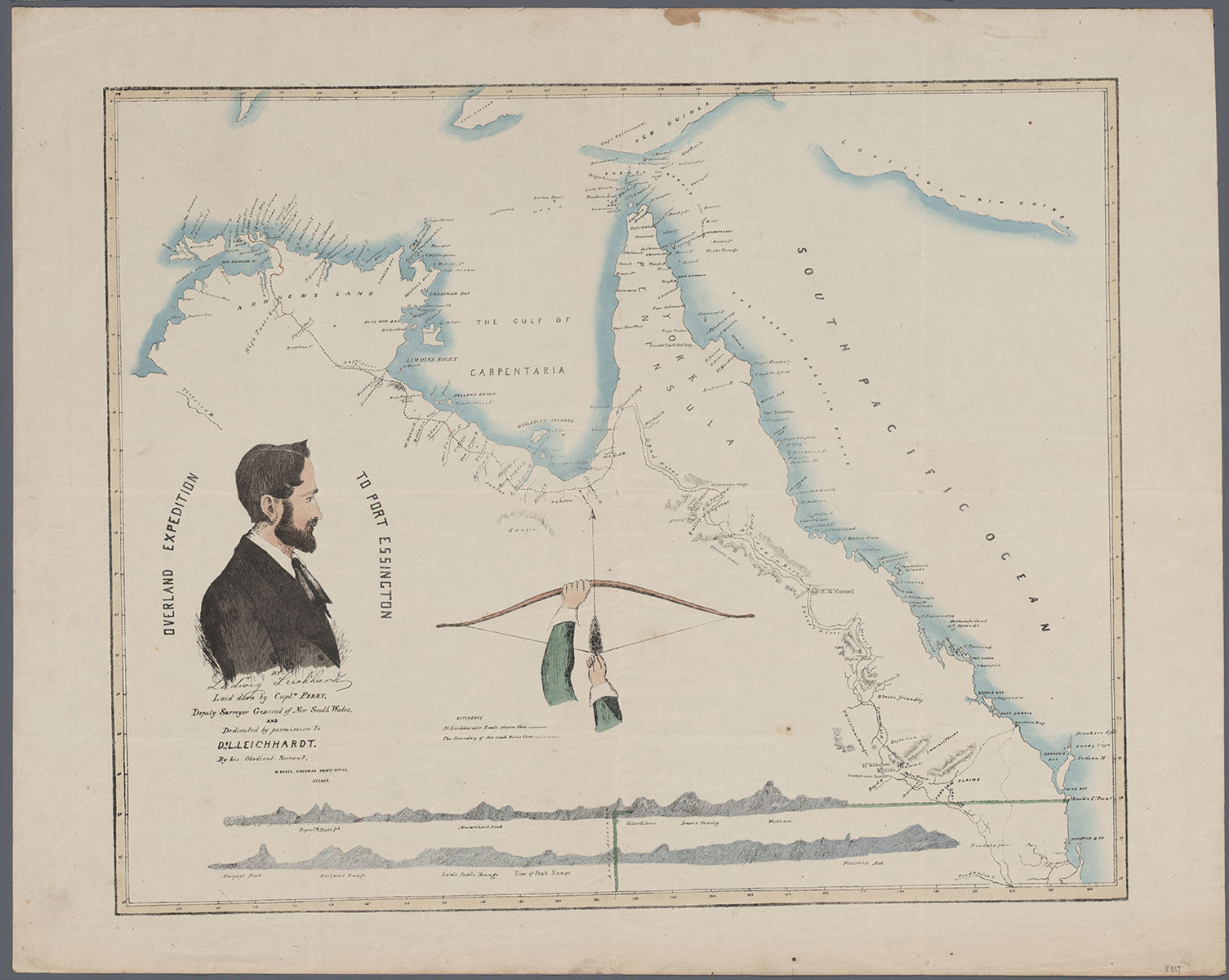
After a recent visit to Ludwig Leichhardt’s historic marker at Roper River in the western Gulf of Carpentaria, I was curious to explore a deeper history of the area. So, I bought a copy of Leichhardt’s detailed expedition journal and downloaded this map of his epic 1844-45 expedition from Brisbane, QLD to Port Essington, NT. His route soon established the ‘Coast Track’, much of it still followed by the modern Savanah Way. Next time, I’ll be much better informed.
STUART 1862 - Northern sheet of the discoveries by John McDouall Stuart showing his route across the centre of the continent of Australia:

As a desert explorer and adventurer, I am profoundly inspired by the epic quests of some of our most courageous and tenacious explorers. Men like John McDouall Stuart who persisted across six expeditions (1858-1862) to create the North-South route known as Stuart’s Track through the centre of Australia; never losing a man in the process. Or Warburton and Forrest who in 1873 and 1874 respectively, each mapped a path from the centre to the west across our vast western deserts. A key to their success often lay in their ability to find water.
BERESFORD 1874 - Map showing route of exploring party under command of Colonel P.E. Warburton, from the centre of the continent to Roebourne, Western Australia:

PETERMANN 1876 – The Latest Voyages of Discovery in the Interior of Australia by Warburton, Giles, Forrest – April 1873 to Sept 1874 (German translation):

Part of the fun is matching the map to the modern location names found on the likes of Hema’s Great Desert Tracks series, even better when you can use these old maps to rediscover campsites, water points and landmarks on your own desert expeditions. Stand at a historic waypoint and imagine what it was like to navigate this vast country without any modern map or GPS.
So next time you plan an outback adventure be sure to download your very own treasure map and add an extra layer of richness to your journey. Who knows what you might just rediscover!
To view, download or order a printed copy of any one of 84,000 free online maps, head to Trove and use the extensive catalogue search tools. Trove is a collaboration of the National Library of Australia and hundreds of partner organisations around Australia.
‘To a person with imagination, a map is a window to adventure’ Sir Francis Chichester.
Next steps
At Hema Maps, we strive to provide the most comprehensive and accurate maps and guides for outdoor enthusiasts looking to explore Australia's natural wonders.
Did you find this information useful? If so, please share it with your fellow explorers. Whether it's by sms, social media, or email, your friends and fellow adventurers will appreciate the valuable tips and insights we've shared.
Let's work together to make the most of every adventure.


